Our Journey to the West continues...
At the bottom you can see where I captured the cute Prairy Dogs amidst the Buffalos!
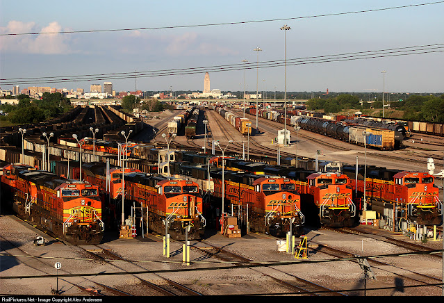
When leaving from our Hyatt Place Lincoln/Downtown–Haymarket, we turned onto Interstate 80 and were IMPRESSED by the HUGE TRAIN YARD!!!
~
What a great start of the day such a view!
Lincoln, Nebraska Train Yard ←click for 30 seconds video
From Haymarket Lincoln, we went west onto Interstate 80.
AND the maximum speed on Interstate 80 was 80 miles or 129 km!
The HUGE difference is that out West there is hardly any traffic, compared to the East...
Here you see a more enlarged view of that HUGE RAIL YARD!BNSF Ravenna Subdivision
Lincoln, Nebraska–Railfanning and Railroading Hotspot ←click for more information.
Nebraska: A Crossroads and a Gateway – Inbound Logistics
Positioned at the heart of the NAFTA trade corridor, Nebraska's Interstate 80 and connecting interstate roadways offer easy, direct transportation to major east–west markets. And two Class I railways—Union Pacific (UP) and Burlington Northern Santa Fe (BNSF)—operate on more than 4,000 miles or 6,437 km of track in the state.
Passing on Interstate 80 Kirkpatrick Basin North State Wildlife Management Area
From Interstate 80 we turn right towards the north after crossing South Channel Platte River and Morman Island State Recreation Area ont US 35 and US 281, where we cross North Channel Platte River
Around 10:00 I'd spotted a Walmart Super Center and Pieter got us some fresh mandarins; easy to peel and have as a healthy snack in the car.
This was at Grand Island, Nebraska
Grand Island...
From US 281 we now turn onto Nebraska 2
Here our 272 miles or 438 km scenic highway through paradise starts: Sandhills Journey National Scenic Byway ←click for short 40 seconds video.
Sandhills Journey National Lincoln, Nebraska Train Yard ←click for 30 seconds video, Nebraska Train Yard ←click 30 seconds video Byway
The Nebraska 2 follows mainly along the Rail Track and South Loup River
Nature was quite interesting as we passed e.g. Ravenna Lake State Recreation Area
Broken Bow an interesting little town.
Near Dunning, we turn and are now following alongside the Middle Loup River and railroad track
Just had to get out of the car to capture this beautiful nature and as you see, our weather couldn't have been any lovelier!
To get a real good view of where I was driving; this short video by drone lets you see → The Nebraska Sandhills, The Middle Loup River, by Sheriff Mike
We passed the small town of Hyannis and several Lakes
The Nebraska 2 is pretty much a two–lane road and we got to admire all our truck divers that transport and deliver the goods for the industry and for households!
This was near Ashby, Nebraska—BNSF (Burlington Northern Santa Fe) Sandhills Subdivision
It was 13:02 and getting hot! 102°F or 39°C near Ashby!
Passing Alliance with its extensive rail yard.
Spring Rails in the Sandhills, Fly with Mike ←3:56 min video by drone for getting an idea where I was driving in Nebraska.
BNSF ←click for link
Rail is the most environmentally efficient mode of surface transportation. On average, BNSF trains can move one ton of freight more than 480 miles on only one gallon of diesel fuel. Our customers reduce their own total carbon emission by shipping with BNSF instead of putting trucks on the highway.
Both of us were stunned for seeing one BNSF train standing still as I passed it and measured on my Relive at full 2 km length or 1.2 mi.
There is so much to see along this scenic byway!!! And to LEARN...
We saw signs along the road with a COW on, not a deer.
This short drone video explains WHY: → The life of a Sandhills Nebraska Sheriff, 2019, by Sheriff Mike
Those Ranchers are the real cowboys!
We mainly saw the black cows and they graze on enormous prairies...
And yes, we both learned about SUMMER HEAT! View this drone video → Summer Heat in the Sandhills, Featuring the Hubsan ACE SE drone, Fly with Mike
Nebraska's Sandhills in Transition ←click link
Photo taken through my open window at traffic light in Alliance, Nebraska on 124 W Third Street.
blue sky...
Now we're on US 385 near Chadron Creek Ranch State Wildlife Management Area
We both admired the famous Ponderosa Pines!
And yes, it was HOT—111°F or 43.8°C
This is where the above photo was taken, on US 385 going north.
It was in this north–western part of Nebraska that I almost got blown off the road by AN EXTREME STRONG WIND GUST! WOW, that was a scare and luckily I held the steering wheel with both hands and with stretched arms, as we were taught in The Netherlands. Hah, that would also explain that we did not see ONE motor bike, they would get blown off the road by such a strong prairie wind!
Even felt it in my upper–arm muscles, from holding the steering wheel...
How will their harsh winters be like here? One thing we learned about the Midwest and West is the STRONG WINDS...
You also better take EVERY opportunity to gas up when you see a gas station— it is so stretched out!
Yay, now we're entering South Dakota into Buffalo Gap National Grassland...!
We would pass through Hot Springs, South Dakota and then into the most amazing nature...
Around 15:50 we spotted our first Buffalos —what a sight!
Buffalos everywhere, as far as you could see!
They have the right of way when crossing the road...
For this photo I'd walked across the road, after parking our car.
Do you see the Prairie dog, lower right, next to that mound?
I immediately picked up their shrill, high voices as they call for danger (not me!)...
Here you again see a Prairie dog, to the left of that mound.
Entering Wind Cave National Park—so much to see and visit here!
What a wonderful area, Wind Cave National Park is right below Custer State Park and we drove up via Hot Springs to our final destination for the day: Custer, South Dakota.
Now Pieter was studying the Prairie dogs and buffalos with the use of our binoculars.
Meanwhile I walked towards some mounds with Prairie dogs.
Enjoy this 13 seconds video:
Gassing up for next day, as I always did for a good start.
We're now at our destination in Custer, South Dakota
We arrived at our hotel for 2 consecutive nights...
I had not that much choice, when making my booking!
Best Western Buffalo Ridge Inn is okay but not very good.
Do you see those stairs to the right? Just left of that car...
I had not looked well enough at this image on their home page, for realizing that there were NO elevators!
And yes, Murphy's Law had us stay at room 220 and I had to haul our things UP those stairs and it is at an elevation of 1,620 m or 5249 feet in the Black Hills of South Dakota...
The result was a very upset mid–back for several days!
Thanks for traveling with us and hoping this did bring some information about these vast states.
Stay tuned for our next day's adventure...
Our day's journey from Lincoln, Nebraska into South Dakota and staying in Custer.
Our progress for the day 809.1 km or 502 mi and a lot of climbing got done as well...
Enjoy our 2 min. short Relive video:


